| Australian Soil Resource Information System |
 |
| Themes - Atlas of Australian Acid Sulfate Soils |
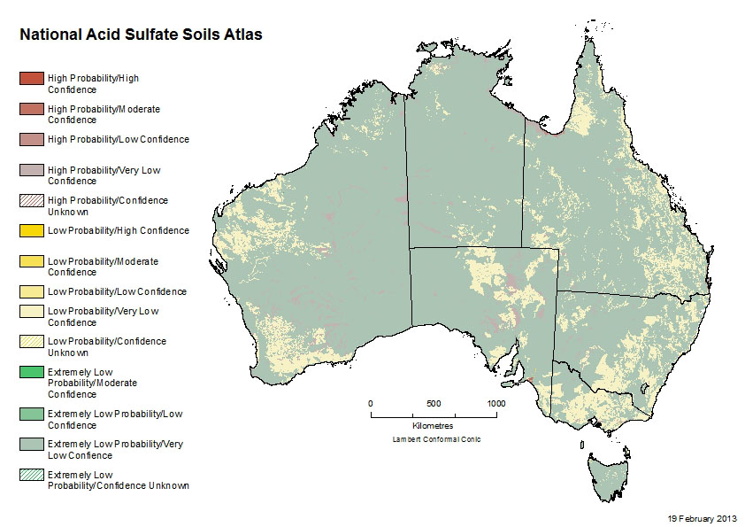
Atlas of Australian Sulfate SoilsAtlas of Australian Acid Sulfate SoilsThe Atlas of Australian Acid Sulfate Soils was compiled by CSIRO to provide a consistent national collation of Australia's acid sulfate soils. The acid sulfate soil (ASS) mapping is classified with a nationally consistent legend that includes risk assessment criteria and correlations between Australian and International Soil Classification Systems.
Overview of the Atlas of Australian Acid Sulfate Soils showing coastal and inland occurences MethodsExisting digital datasets of ASS mapping have been sourced from each coastal state and territory and combined into a single national dataset. Original state classifications have been translated to a common national classification system by the respective creators of the original data and other experts. This component of the Atlas is referred to as the “Coastal” ASS mapping. The remainder of Australia beyond the extent of state ASS mapping has been “backfilled” with a provisional ASS classification inferred from national and state soils, hydrography and landscape coverages. This component is referred to as the “Inland” ASS mapping.
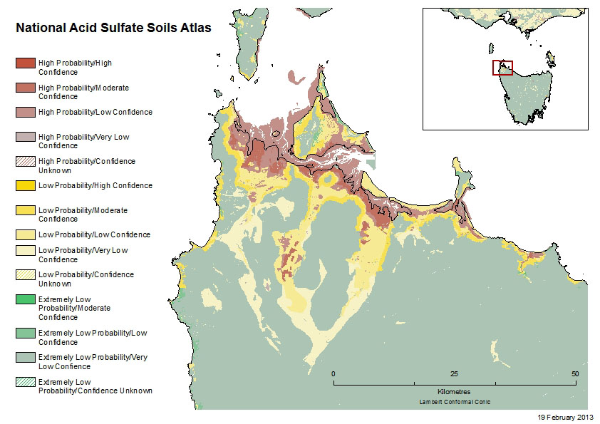
Detailed coastal acid sulfate soil mapping in north west Tasmania For the state Coastal ASS mapping, the mapping scale of source data ranges from 1:10K aerial photography in SA to 1:250K vegetation mapping in WA and NT, with most East coast mapping being at the 1:100K scale. For the backfilled inferred Inland ASS mapping the base scale is 1:2.5 million (except Tas.) overlaid with 1:250k hydography. As at 06/08, the Tasmanian inland mapping has been re-modelled using superior soil classification map derived from 1:100k landscape unit mapping. MetadataMetadata is available on the CSIRO Data Access Portal. An extended metadata document that contains detailed legend definitions and references is also available (PDF 170 KB) DownloadsThe Atlas of Australian Acid Sulfate Soils can be downloaded from the CSIRO Data Acess Portal. The dataset is available as an ESRI File Geodatabase (200 MB) or as a shapefile (390 MB) |