| Australian Soil Resource Information System |
 |
| Themes - Atlas of Australian Soils |
Atlas of Australian Soils
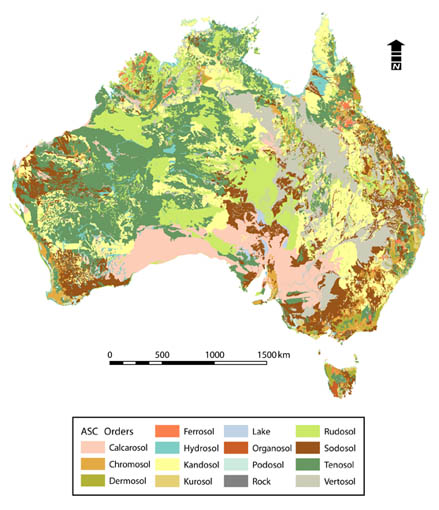
Atlas of Australian SoilsThe Atlas of Australian Soils (Northcote et al, 1960-68) was compiled by CSIRO in the 1960's to provide a consistent national description of Australia's soils. It comprises a series of ten maps and associated explanatory notes, compiled by K.H. Northcote and others. The maps are published at a scale of 1:2,000,000, but the original compilation was at scales from 1:250,000 to 1:500,000. Mapped units in the Atlas are soil landscapes, usually comprising a number of soil types. The explanatory notes include descriptions of soils landscapes and component soils. Soil classification for the Atlas is based on the Factual Key. The Factual Key (Northcote 1979) was the most widely used soil classification scheme prior to the Australian Soil Classification (Isbell 2002). It dates from 1960 and was essentially based on a set of about 500 profiles largely from south-eastern Australia. It is an hierarchical scheme with 5 levels, the most detailed of which is the principal profile form (PPF). Most of the keying attributes are physical soil characteristics, and can be determined in the field. Digital atlas of Australian SoilsIn 1991, a digital version of the Atlas was created by the Bureau of Rural Science from scanned tracings of the published hardcopy maps. The Digital Atlas of Australian Soils is available as a shapefile. Additionally, there is a reliability map available, with a descriptive legend. The source of the reliability data is unknown. Download the Digital Atlas of Australian Soils (29 MB) Download includes:
Download the Digital Atlas of Australian Soils reliability data (1 MB) Download includes:
MetadataMetadata is provided in the ANZLIC2.0 metadata standard, as a Microsoft Word document. Reports and caveats specific to interpretations are contained within the relevant data downloads. Download the Atlas of Australian Soils metadata (48 KB) Interpretations, Reports and look-up tablesInterpretations of the mapping units have led to the development of look-up tables for the atlas. It is important to note the many caveats attached to these. Tables are supplied as ascii, comma delimited. Care must be taken when joining/linking the tables to the data, due to the use of mixed case in mapping unit names. Microsoft Access can not discern the difference between “m” and “M”. ESRI software (originally written for UNIX) is able to do this match via the join utility.
ReferencesAshton, L.J. and McKenzie, N.J. (2001). Conversion of the Atlas of Australian Soils to the Australian Soil Classification, CSIRO Land and Water (unpublished). Isbell, R. F. (2002). The Australian Soil Classification. Revised Edition. CSIRO Publishing, Melbourne. Isbell, R.F., McDonald, W.S., Ashton, L.J (1997) Concepts and rationale of the Australian Soil Classification. ACLEP, CSIRO Land and Water, Canberra. McKenzie, N. J. and Hook, J. (1992). Interpretations of the Atlas of Australian Soils. Consulting Report to the Environmental Resources Information Network (ERIN). CSIRO Division of Soils Technical Report 94/1992. McKenzie, N.J., Jacquier, D.W., Ashton L.J. and Cresswell, H.P. (2000) Estimation of Soil Properties Using the Atlas of Australian Soils. CSIRO Land and Water Technical Report 11/00. National Resource Information Centre (NRIC) (1991). The Digitial Atlas of Australian Soils – scanned tracings. (unpublished). Northcote, K. H. with Beckmann, G. G., Bettenay, E., Churchward, H. M., Van Dijk, D. C., Dimmock, G. M., Hubble, G. D., Isbell, R. F., McArthur, W. M., Murtha, G. G., Nicolls, K. D., Paton, T. R., Thompson, C. H., Webb, A. A. and Wright, M. J. (1960-1968). Atlas of Australian Soils, Sheets 1 to 10. With explanatory data (CSIRO Aust. and Melbourne University Press: Melbourne). Northcote, K.H. (1979). A Factual Key for the Recognition of Australian Soils. 4th edn., Rellim Technical Publishers, Glenside, SA. DownloadsDigital Atlas of Australian Soils (29 MB) Digital Atlas of Australian Soils reliability dataset (1 MB) Atlas of Australian Soils metadata (48 KB) PPF interpretations (McKenzie and Hook, 1992) (1 MB) Australian Soil Classification conversion (Ashton and McKenzie, 2001) (16 KB) |