Help Contents
- Getting Started
- ASRIS Maps Overview
- What are Map Layers?
- Visible and Active
Layers
- Main Toolbar
- Layers with Hyperlinks
- Extracting Layers
- Addtional Tools
- System Requirements
Getting started (click on a heading
to view a presentation)
- Navigation in ASRIS
(3MB WMV)
- Viewing soil maps at different
scales (4MB WMV)
- Contextual information
to help with interpretation (4MB WMV)
- Producing
statistical summaries (4MB WMV)
- Representative
soil profiles - images and detailed data (3MB WMV)
- Customised queries (3MB WMV)
- Printing
maps and exporting images (3MB WMV)
ASRIS Maps Overview
View the maps window in the maximised setting. When the maps window
is open, the address bar and toolbar will not be visible. This
avoids conflicts with forward and back buttons. The browser tools
will reset when you open a new window.
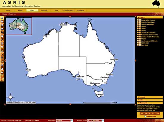
The maps window (shown below) has a display area and various
tools for navigation and querying. The overview map at the top
left is a locator and can be used for panning. The main toolbar
is on the left hand side of the window. The layer list on the
right of the screen can be toggled to display the map legend.
Press the "Refresh Map" button after changing the layer
settings.
What are Map Layers?
The ASRIS map window provides access to a Geographic Information
System via the web. The maps are created in response to the settings
you specify with the buttons and selectors. Map layers are the
different sets of information that can be added to your map. The
system can add and subtract layers from the map according to the
scale. This stops your map becoming cluttered with lots of fine
detail when large areas are being viewed.
There are several types of layers:
- Map information layers: These are features common
to all maps (e.g. coastlines, roads, rivers, town locations).
They are usually points, lines or shapes. Many of these layers
can be displayed at one time.
- Images: These are digital pictures that act as backdrops
to the map. They include Landsat mosaics, shaded DEMs and topographic
maps. These can only be displayed one at a time. The image highest
on the layer list masks the others.
- Tract Layers: These layers show the boundaries of
soil map units. Tract layers are defined at Levels 1-5 in the
ASRIS hierarchy.
- Soil attribute layers: These layers contain soil
information for the range of soil attributes outlined in the
ASRIS Technical Specifictions. The same soil attribute can be
displayed at a range of scales (i.e. different levels of the
hierarchy) and in different reporting frameworks (e.g. IBRA
or NHT boundaries).
To access the metadata for a layer, click on the layer name
in the layer list. To Search for ASRIS metadata click here.
Visible and Active Layers
A visible layer can be displayed on the map. To make
a layer visible, check the box next to the layer and click the
"Refresh Map" button.
To remove a layer from the map display area, uncheck the box
next to the layer and click the "Refresh Map" button.
A layer is set to active if the user wants more information.
To make a layer active, click on the page icon next to the layer.
Only one layer can be interrogated at a time. Once active, a layer
can be interrogated using tools from the toolbar (e.g. query,
hyperlink). The Identify tool has the ability to drill down through
all visible layers and provide attribute information for the location
of interest.
Main Toolbar
The main toolbar is on the left of the maps windows. Placing
the mouse pointer over a tool will display its function. The active
tool is named in the red bar above the map window.
 |
Zoom In: Zooms to the region
that you click or drag a box around |
 |
Zoom Out: Zooms out from the region
that you click or drag a box around |
 |
Zoom to Full Extent: Zooms to the full
extent of the map
|
 |
Zoom to Active Layer: Zooms to the full
extent of the active layer
|
 |
Back to Last Extent: Zooms to the previous
extent
|
 |
Pan: Pans the display in the direction
that you drag the mouse pointer
|
 |
Hyperlink: Displays graphs and PDF documents
relating to the active layer
|
 |
Identify: Displays attribute information
in a table below the map for the feature identified by clicking
|
 |
Query: Searches for features based on
a query expression
|
 |
Measure: Measures distances on the map
in kilometres
|
 |
Select by Rectangle: Selects a group
of features bounded by or in contact with a rectangle drawn
on the map
|
 |
Select by Line/Polygon: Selects a group
of features bounded by or in contact with a line or polygon
drawn on the map
|
 |
Clear Selection: Clears the selected
set of features
|
 |
Print: Prints the map to your default
printer
|
 |
Toggle Overview Map: Adds or removes
the overview map from the top left corner of the map display
|
 |
Extract: Downloads visible layers as
ESRI shape files to your computer (polygon layers only)
|
 |
Toggle ASRIS Banner: Adds or removes
the ASRIS banner to create a different sized map display
|
 |
Toggle TOC: Adds or removes the Layer/Legend
frame to create a different sized map display
|
 |
Lime Tool: Displays the Liming and Soil Acidification Calculators (L5 pH Layer 1 must be visible and active)
|
Layers with Hyperlinks
ASRIS includes hyperlinks to additional data. To invoke hyperlinks,
make the the layer of interest visible and active, then select
the hyperlink tool from the toolbar and click on the feature of interest. The following table summarizes
layers with hyperlinked data.
Layer Name |
Hyperlink Type |
Landscape Gallery |
Landscape photographs for a range of Australian environments. |
Reference Profiles |
Soil profile image, morphological description, soil chemical
data, site image and site description (PDF and RTF formats). Available for
selected sites accross the nation. |
Level 5 Tracts |
Soil description and soil chemical data for representative profiles for the selected land unit where available (various file formats). |
Level 5 Projects |
Soil survey project metadata for the selected project. |
Level 4 Tracts |
Soil description and soil chemical data for representative profiles for the selected land unit where available (various file formats). |
Level 5 Projects |
Soil survey project metadata for the selected project. |
Attributes at Levels 3-5 |
Histogram of the data used to determine the value assigned
to the feature. All feature values are area-weighted means
except for nominal attributes (e.g. Australian Soil Classification)
and these are assigned by dominance. |
WNSW Land Systems |
Description of the landsystem. |
NSW Riverine Plains |
Description of the landsystem (PDF). |
Tas Land Systems |
Description of the landsystem (PDF). |
National Acid Sulfate Soil Atlas |
Metadata and complete legend (MS Word). |
Acid Sulfate Soil Reference Sites |
Site reports with detailed morpgological and analytical data (PDF). |
APSIM Reference Sites |
Input data for the APSIM-SoilWat water balance model
(MS Excel). |
L5 Tracts APSIM |
Input data for the APSIM-SoilWat water balance model
(MS Excel). |
CSIRO Soil Archive |
Soil morphological and soil chemical descriptions for all soil archive sites (RTF format). |
Extracting Layers
This facility is currently unavailable.
Addtional Tools
 Layer
Layer
|
Toggle between Layer List
and Legend: Switches back and forth between the
map legend and list of layers |
 Legend
|
Help
|
Hide/Show Help: Displays the help menu |
Messages
|
Hide/Show Messages: Displays the scrolling
messages |
| |
Refresh Map: Refreshes the map according
to the selections in the layer list above |
| |
Pan to N, NE, E, SE, S, SW, W: Pans
the map in the slected direction |
System Requirements
Supported Operating Systems and Browsers:
 Macintosh 9.2, OS X, OS 10.2 using MSIE v.4 - 6, Netscape v.4.7
- 7, Mozilla v.1.0 - 3.0, Safari 1.2, Firefox 1.0
Macintosh 9.2, OS X, OS 10.2 using MSIE v.4 - 6, Netscape v.4.7
- 7, Mozilla v.1.0 - 3.0, Safari 1.2, Firefox 1.0
 MS Windows 98, 2000, XP, VISTA, 7 using MSIE v.4 - 10 or Netscape v.4.7 -
7, Mozilla Firefox v.1.0 - 12.0
MS Windows 98, 2000, XP, VISTA, 7 using MSIE v.4 - 10 or Netscape v.4.7 -
7, Mozilla Firefox v.1.0 - 12.0
 Linux 3.0 using Mozilla v.1.7 and Galeon v.1.2.5
 Solaris using Netscape v.4.7 - 7
Other browsers have not been tested and they may not run ASRIS.
The ASRIS web application works best with 15" - 1024X768
dpi monitors or larger. |

